Monday, December 21, 2009
Wednesday, December 16, 2009
Wednesday, December 9, 2009
Sunday, November 22, 2009

Wednesday, November 4, 2009
Green University: Saudi Arabia’s KAUST With Eco-Friendly Environment

With the opening of the new King Abdullah University of Science and Technology, otherwise known as KAUST, a new era in academic learning, combined with new innovations in ecological architecture and design, has begun in which both men and women students will benefit jointly.
The new campus opened its doors in September in the Red Sea city of Thuwal. The Campus is constructed in a manner to utilize the maximum benefit of sea breezes for cooling, the buildings have been constructed in order to screen out a good amount of the heat that is generated by the hot Arabian sun; making the internal environment more sustainable for the students.
The new campus opened its doors in September in the Red Sea city of Thuwal. The Campus is constructed in a manner to utilize the maximum benefit of sea breezes for cooling, the buildings have been constructed in order to screen out a good amount of the heat that is generated by the hot Arabian sun; making the internal environment more sustainable for the students.
Tuesday, November 3, 2009
Thursday, October 29, 2009
India offers to share satellite data with ASEAN countries
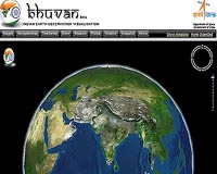
India offered to help South East Asian nations in management of natural disasters by sharing satellite data for the region and launch small satellites built by them."We would be ready to share satellite data for management of natural disasters, launch small satellites and scientific instruments and payloads for experiments in remote sensing and communication for space agencies and academic institutions in ASEAN countries," Prime Minister Manmohan Singh said.The Indian Space Research Centre (ISRO) has one of the largest constellation of advanced remote sensing satellites in the world which orbit the earth at regular intervals. Images of the earth received from these satellites can be utilised for disaster management initiatives in the ASEAN region, parts of which are prone to cyclones and earthquakes.
Tuesday, October 20, 2009
Killer Algae was Key Player In Mass Extinctions

A new theory suggests lowly algae may be the killer behind the world's great species annihilations. Anywhere there is water, there can be toxic algae. The microscopic plants usually exist in small concentrations, but a sudden warming in the water or an injection of dust or sediment from land can trigger a bloom that kills thousands of fish, poisons shellfish, or even humans.
James Castle and John Rodgers of Clemson University think the same thing happened during the five largest mass extinctions in Earth's history. Each time a large die off occurred, they found a spike in the number of fossil algae mats called stromatolites strewn around the planet.
James Castle and John Rodgers of Clemson University think the same thing happened during the five largest mass extinctions in Earth's history. Each time a large die off occurred, they found a spike in the number of fossil algae mats called stromatolites strewn around the planet.
Monday, October 12, 2009
Thursday, October 8, 2009
Online atlas to map Indian state’s biodiversity 8 October 2009
The Karnataka Biodiversity Board (KBB) is preparing an online atlas of the state’s biodiversity. The atlas, the first of its kind in the country, will provide information about the diversity of Karnataka’s wildlife species and their habitats and help researchers, resource managers, decision-makers and the public. This would help conservation planning and decisionmaking.The KBB official said that once the atlas was ready, any individual, group or agency concerned about biodiversity and interested in protecting the diverse species and habitats in the state, could access a range of data under one umbrella.The board has identified four organisations— Atree (Ashoka Trust for Research in Ecology and the Environment), Bangalore University, EMPRI (Environment Management and Policy Research Institute) and the Forest College of the Agriculture University— for the development and maintenance of this atlas.The National Biodiversity Board would be the primary funding agency for this project. Institutions involved in the project would prepare their respective cost estimates.
Monday, September 28, 2009
Iran test-fires missiles amid nuclear tension
Iran test-fired missiles to show it was prepared to head off any military threat, four days before the Islamic Republic is due to hold rare talks with world powers worried about its nuclear ambitions.
It coincide with escalating tension in Iran's nuclear row with the West, after last week's disclosure by Tehran that it is building a second uranium enrichment plant.
click to read more
It coincide with escalating tension in Iran's nuclear row with the West, after last week's disclosure by Tehran that it is building a second uranium enrichment plant.
Sunday, September 27, 2009
Thinning Of Greenland And Antarctic Ice
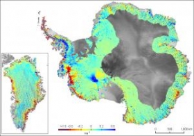
Reporting in the journal Nature, researchers from British Antarctic Survey and the University of Bristol describe how analysis of millions of NASA satellite measurements* from both of these vast ice sheets shows that the most profound ice loss is a result of glaciers speeding up where they flow into the sea.
Sunday, September 20, 2009
Everest "memento" for Obama to show climate change impact
Nepal's sherpa community is sending a piece of rock from Mount Everest to U.S. President Barack Obama to underscore the impact of global warming on the Himalayas.
Environmental group WWF said Prime Minister Madhav Kumar Nepal had promised to carry the "memento" and give it to Obama when world leaders meet in New York next week as "a symbol of the melting Himalayas in the wake of climate change."
Heads of state will attend a U.N. General Assembly meeting as well as hold talks on climate change in New York.
The rock was collected from the 8,850 meter (29,035 feet) Mount Everest by Apa Sherpa, who climbed the mountain for a record 19th time in May.
Saturday, September 19, 2009
Saturday, September 12, 2009
Tuesday, September 1, 2009
Monday, August 31, 2009
Ganges River Dolphin Survival Threatened by Oil Exploration

Dolphin protected areas must be established if the Ganges River dolphin is to survive in the Brahmaputra river system, new research indicates. The study was prompted by the need for accurate dolphin population data after Oil India Ltd. proposed to start prospecting for oil along the bed of the Brahmaputra River using air guns and explosives.
Such prospecting "has potentially disastrous implications for Ganges River dolphins," the report concludes.Estimates have put the total population of the Ganges River dolphin, Platanista gangetica gangetica, at around 2,000. Between 240 to 300 of these inhabit the Brahmaputra River system in India, according to the survey prepared for the International Union for the Conservation of Nature's Sir Peter Scott Fund.
Such prospecting "has potentially disastrous implications for Ganges River dolphins," the report concludes.Estimates have put the total population of the Ganges River dolphin, Platanista gangetica gangetica, at around 2,000. Between 240 to 300 of these inhabit the Brahmaputra River system in India, according to the survey prepared for the International Union for the Conservation of Nature's Sir Peter Scott Fund.
Saturday, August 22, 2009
Oil spill sparks evacuation off Australian coast

SYDNEY (Reuters) - An oil leak off Australia's western coast has sparked the evacuation of dozens of workers from a rig, the operator PTTEP Australasia said .
Thursday, August 20, 2009
Saturday, August 15, 2009
Tuesday, August 11, 2009
Friday, August 7, 2009
Wednesday, July 22, 2009
Asia darkens under longest solar eclipse of century

A total solar eclipse on Wednesday swept across a narrow swathe of Asia, where hundreds of millions of people watched the skies darken, though in some places thick summer clouds blocked the sun.
The longest total solar eclipse of the 21st century cut through the world's most populous nations, India and China, as it travelled half the globe. It was visible along a roughly 250 km-wide (155 miles) corridor, U.S. space agency NASA said.In India, where eclipse superstitions are rife, people snaked through the narrow lanes of the ancient Hindu holy city of Varanasi and gathered for a dip in the Ganges, an act believed to bring release from the cycle of life and death.Amid chanting of Hindu hymns, thousands of men, women and children waded into the river with folded hands and prayed to the sun as it emerged in an overcast sky."We have come here because our elders told us this is the best time to improve our afterlife," said Bhailal Sharma, a villager from central India travelling in a group of about 100.But for one 80-year-old woman the trip was fatal. Police said she died from suffocation in the crowd of hundreds of thousands that had gathered to bathe in the Ganges.The eclipse next swept through Bangladesh, Nepal, Bhutan, Myanmar and over the crowded cities along China's Yangtze River, before heading to the Pacific.In Hindu-majority Nepal, the government declared Wednesday a public holiday and thousands headed for water.
The longest total solar eclipse of the 21st century cut through the world's most populous nations, India and China, as it travelled half the globe. It was visible along a roughly 250 km-wide (155 miles) corridor, U.S. space agency NASA said.In India, where eclipse superstitions are rife, people snaked through the narrow lanes of the ancient Hindu holy city of Varanasi and gathered for a dip in the Ganges, an act believed to bring release from the cycle of life and death.Amid chanting of Hindu hymns, thousands of men, women and children waded into the river with folded hands and prayed to the sun as it emerged in an overcast sky."We have come here because our elders told us this is the best time to improve our afterlife," said Bhailal Sharma, a villager from central India travelling in a group of about 100.But for one 80-year-old woman the trip was fatal. Police said she died from suffocation in the crowd of hundreds of thousands that had gathered to bathe in the Ganges.The eclipse next swept through Bangladesh, Nepal, Bhutan, Myanmar and over the crowded cities along China's Yangtze River, before heading to the Pacific.In Hindu-majority Nepal, the government declared Wednesday a public holiday and thousands headed for water.
Tuesday, July 21, 2009
Sunday, July 19, 2009
Are Aluminum Bottles Greener than Glass?

Aluminum as a substitute for glass bottles has been inching its way into the consumer experience in the last few years, most notably in the US in the form of beer bottles from Anheuser-Busch and Iron City Beer, a popular regional brand founded in Pittsburgh. Coca-cola has also announced plans to roll out aluminum bottles in this country, though only in limited venues.
Now Rexam, one of the world’s largest consumer packaging companies, has developed a lighter, resealable aluminum bottle that it hopes will replace glass bottles for many beverages, including wine.
Tuesday, July 14, 2009
Environmental Scientists Use Fish Behavior To Monitor Water Quality
Researchers are using bluegills to detect industrial and agricultural spills in water supplies. Changes in the environment cause the fishes' behavior and breathing patterns to change. Electrodes are placed inside the tanks that contain the fish and water from a nearby water supply, and they set off an alarm if conditions inside the tank change.
Monday, July 13, 2009
DubaiSat-1 reaches launch pad in Kazakhstan

The first remote sensing satellite developed by a UAE entity - the Emirates Institution for Advanced Science & Technology (EIAST) has been shipped from its development base in South Korea to the launch pad in Baikonour in Kazakhstan. DubaiSat-1 is a stepping stone in the UAE's attempt to create a sound infrastructure that enables the collection of space and earth observation data to power the comprehensive development of the nation. The satellite highlights the commitment of EIAST to create a knowledge based economy by leveraging the advances in satellite technology.The launch of DubaiSat-1 consists of three segments; space, ground and actual launch. The ground segment comprises mission control station, image receiving and processing station, and antenna and RF subsystem.
Tuesday, July 7, 2009
NAVTEQ’s first map of Egypt
NAVTEQ released first Intermediate map for Egypt. The product will represents the highest 3rd party data available published in standard formats supported by NAVTEQ globally.With this Intermediate Map of Egypt, drivers will have access to approximately 50,000 km of roads and more than 42,000 POIs referenced to the map to enhance the functionality of navigation systems.Egypt has a very complex road network, strong tourism industry and is one of the region's most populous nations, with an estimated population of 78.3 million inhabitants. The Intermediate Map of Egypt has been designed to meet the evolving needs of the growing user base. Intermediate Maps are a separate class of map data provided by NAVTEQ to support customers who are interested in introducing LBS and navigation applications in emerging markets. The launch of Egypt further demonstrates NAVTEQ's ongoing commitment to the region. Future plans include upgrading Egypt to a NAVTEQ map. To accomplish this, NAVTEQ's geographic analysts will drive the roads to collect and verify up to 260 attributes, resulting in the highest quality navigable map and a foundation for new content.
Wednesday, July 1, 2009
Saturday, June 20, 2009
Scientists Show Bacteria Can 'Learn' And Plan Ahead

Bacteria can anticipate a future event and prepare for it, according to new research at the Weizmann Institute of Science. In a paper that appeared June 17 in Nature, Prof. Yitzhak Pilpel, doctoral student Amir Mitchell and research associate Dr. Orna Dahan of the Institute's Molecular Genetics Department, together with Prof. Martin Kupiec and Gal Romano of Tel Aviv University, examined microorganisms living in environments that change in predictable ways.
Thursday, June 18, 2009
Mounting evidence shows native grasses could destroy explosives pollution
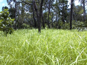
The notion started with mounting evidence that native grasses could render harmless a common weed killer.....
Monday, June 15, 2009
Sunday, June 14, 2009

Wednesday, June 10, 2009
Global Warming: Heat Could Kill Drought-stressed Trees Fast

Widespread die-off of piñon pine across the southwestern United States during future droughts will occur at least five times faster if climate warms by 4 degrees Celsius, even if future droughts are no worse than droughts of the past century, scientists have discovered in experiments conducted at the University of Arizona's Biosphere 2.
Tuesday, June 9, 2009
Sunday, June 7, 2009
Saturday, June 6, 2009
Tuesday, June 2, 2009
Global Bird Species in Serious Decline

Researchers have known about the speckled brown Sidamo lark for only 40 years. Always a rare sight, the elusive bird may soon vanish from the prairie grasses of Ethiopia forever.
Its habitat already restricted to less than 100 square kilometers, the lark is rapidly losing territory as local residents, the Borana ethnic group, convert grassland into heavily grazed pasture. Unless the Borana are allowed to resume their nomadic ways, within the next few years the Sidamo lark will likely become the first known bird species to vanish from mainland Africa, researchers say.
Its habitat already restricted to less than 100 square kilometers, the lark is rapidly losing territory as local residents, the Borana ethnic group, convert grassland into heavily grazed pasture. Unless the Borana are allowed to resume their nomadic ways, within the next few years the Sidamo lark will likely become the first known bird species to vanish from mainland Africa, researchers say.
Monday, June 1, 2009

Thursday, May 28, 2009
Wednesday, May 27, 2009
Wednesday, May 20, 2009
GPS for Guwahati police
Guwahati, Assam: City police will soon have global positioning system (GPS)-aided facility for quick responses to emergency situations. It is part of the computer-aided dispatch system (CADS) launched in 2008.A US-based company, InterAct Public Safety Systems, a provider of comprehensive public safety and homeland security solutions, has already started work on the new system for the police, which is expected to be completed within three months. Work on the project started in December last year, a source in the home department here said. Once complete, the computer-aided dispatch system will be like cities in the US and Canada which have this system for faster response to emergencies. “Installation of hardware and software, electronic mapping of the city and plotting of about 1 lakh land telephone lines have already been completed,” a senior home department official said. He said in the first phase, GPS service would be introduced only to the land phone lines but there are plans also to include the global system mobile (GSM) communications and code division multiple access (CDMA) systems subsequently. “There is a question of availability of funds,” he said adding that if the system clicked and achieved its desired objective, other key towns in the state would also be brought under it. The official said initially about 30 patrol vehicles in the city would be fitted with GPS and would be monitored from the police control room. “We expect that introduction of this new technology would enable swifter responses,” the official said.The geographic information system (GIS) map will be able to show the movement of the 30 vehicles live and the base map would have landmarks like roads, railway lines, buildings, locality, police stations, road intersections. “The GIS will be capable of working with the dial 100 application and would display the respective locality of the origin of the telephone call on the screen. The operator at the control room can immediately inform the nearest patrol vehicle from where the phone call had come,” the official said. The entire operation will work under a BSNL server, the official added. The official said the introduction of the GPS system wo-uld also help city police work with minimum manpower. “It will not only help keep an eye on the movement of the patrolling vehicles but also accurately guide them to the spot when an incident takes place in quick time,” he said. Sources said another big advantage of introducing the GPS system would be that no policeman on patrol duty could lie now since the movement of his vehicle would be monitored round the clock. “Many officers do not visit vulnerable areas despite strict orders to do so. There was no way we could prove them wrong,” the official said. Source : http://www.telegraphindia.com/
Monday, May 18, 2009
Wednesday, May 13, 2009
Global Warming Study: Nations Need to Cut Emissions by 70 Percent

The threat of global warming can be significantly lessened if nations cut emissions of heat-trapping greenhouse gases by 70 percent this century, according to a new study. This would help reduce the most dangerous aspects of climate change including massive losses of Arctic sea ice and permafrost and significant sea level rise, although global temperatures will still rise.
The study, led by scientists at the National Center for Atmospheric Research (NCAR), will be published in Geophysical Research Letters. It was funded by the Department of Energy and the National Science Foundation, NCAR's sponsor.
The study, led by scientists at the National Center for Atmospheric Research (NCAR), will be published in Geophysical Research Letters. It was funded by the Department of Energy and the National Science Foundation, NCAR's sponsor.
"This research indicates that we can no longer avoid significant warming during this century," said NCAR scientist Warren Washington, the lead author for the study. However, a catastrophe can be avoided if the world implements the recommended emission cuts of 70 percent, he said.
Thursday, May 7, 2009
Tuesday, May 5, 2009
Monday, May 4, 2009
New England Rescinds Protections for Threatened Atlantic Sea Turtles

The New England Fishery Management Council voted to rescind protections for threatened and endangered sea turtles, many of which are caught in scallop dredges in New England and mid-Atlantic waters.
Sunday, May 3, 2009
Friday, May 1, 2009
World likely to pass dangerous warming limits
The world will probably exceed a global warming limit which the European Union calls dangerous, scientists at Britain's MetOffice Hadley Centre said , presenting a new, 5-year research program.
But not all scientists agree, demonstrating a shift in debate from whether climate change is happening -- on which where there is near consensus -- to how bad it will get and what to do about it.
Thursday, April 30, 2009
 At roughly 8km wide, Atafu atoll is the smallest of three atolls comprising the Tokelau Islands in the southern Pacific. The islands - just 2m above the tidal high-water level - suffered significant inundation and erosion during Cyclone Percy in 2005. Vulnerability to tropical cyclones and potential sea level rise make the long-term habitability of the atoll uncertain
Monday, April 27, 2009

Sunday, April 26, 2009
Friday, April 24, 2009
Tuesday, April 21, 2009

Saturday, April 18, 2009
Tuesday, April 14, 2009
Monday, April 13, 2009

Thursday, April 9, 2009
Climate Change To Spur Rapid Shifts In Wildfire Hotspots, Analysis Finds

Climate change will bring about major shifts in worldwide fire patterns, and those changes are coming fast, according to a first-of-its-kind analysis led by researchers at the University of California, Berkeley, in collaboration with scientists at Texas Tech University.
The findings are reported in the April 8 issue of PLoS ONE, an open-access, peer-reviewed journal of the Public Library of Science.
Sunday, April 5, 2009
Friday, April 3, 2009
Thursday, April 2, 2009
Wednesday, April 1, 2009

Monday, March 30, 2009
Sunday, March 29, 2009
Tuesday, March 24, 2009
Allahabad Municipal corporation conducts survey using GIS
The Allahabad Municipal Corporation (AMC) has completed the work of the survey of houses through GIS, within the municipal limits of the city. The employees of the tax department of AMC are verifying the houses which are currently added in the new survey and tallying it with the record.
Sources in the AMC said that there are about 1,90,000 houses in the municipal limits which has been mapped through the GIS system. However, the total number of houses registered with the corporation is about 1,66,000.
AMC undertook the survey through GIS to ascertain the number of houses which have come up in recent years. The purpose of the survey is to have a comprehensive record of the different types of the houses, the condition of the roads, the number of lanes in the localities and other details. This exercise has been taken to improve the financial condition of AMC.
Thursday, March 19, 2009
Tuesday, March 10, 2009
Monday, March 9, 2009
Wednesday, March 4, 2009
Thursday, February 26, 2009
Tuesday, February 24, 2009
Wednesday, February 18, 2009
Birmingham digital remapping complete
Birmingham has become the first English city to be completely remapped by its own citizens. Maps of the city are freely editable and available at OpenStreetMap (OSM). The OpenStreetMap project, run by the OpenStreetMap Foundation, is an open source project that is building free online maps, not based on any copyright or licensed map data. Birmingham is not the first city to be remapped in this way, but it is the first city in the United Kingdom.
According to OpenStreetMap, the digital map of Birmingham, is now more up-to-date and accurate than any other online map and only Ordnance Survey can claim to be more accurate, due to the technical and financial resources at their disposal. The data being used by OSM has been obtained from 100 volunteers who collected GPS data while cycling, walking, riding busses and trains and one volunteer even used a canal boat. They have mapped some 15,000 residential roads, 6,000 footpaths and 9,000 other roads in Birmingham (and over 700 bus stops, 300 pubs, 200 traffic lights and 300 postboxes).
Source : http://www.heise-online.co.uk
Tuesday, February 10, 2009
Thursday, February 5, 2009
Seminar on Gandhi
U.G.C. Sponsored National seminar is being organized by Department of Political Science, Amar Singh (P.G) College, Lakhaoti, Bulandshahr, UP, on 24-25 February, 2009. We are requesting you to send your paper along with an abstract latest by 10th Feb., 2009. It would be highly appreciated if you can send your paper with abstract through E-mail ashuparsiya@rediffmail.com; or through registered post with CD, well in advance, so that the same can be published and circulated to the participants. We will publish the papers after the conference in the form of a book.
You are hereby requested to send your paper/article on any aspect of below mentioned themes, these are the tentative topics, you make chose any topic in an around the main theme of the conference.
Main Theme: Gandhi in the 21st Century
Sub themes:
1. Challenges of 21st century and Gandhian alternative
2. Locating Gandhi
3. Gandhi and Globalization
4. Gandhi and Contemporary World
5. Gandhi Science and Technology
6. Gandhi and Social Justice
7. Gandhi and Terrorism
8. Gandhi and Environment
9. Gandhi and Panchayati Raj institution
Saturday, January 31, 2009
Monday, January 26, 2009

Friday, January 23, 2009
Thursday, January 15, 2009
Friday, January 2, 2009
New application offered to maintain oil & gas pipeline GIS data
United States of America, December 22, 2008 -- New Century Software has completed a major software initiative that has merged the functionality of a number of applications into the newly released Facility Manager 2008 software. Facility Manager 2008 allows operators to perform a variety of centerline maintenance functions, including adding new lines, performing pipe reroutes, and merging pipelines, within their pipeline GIS.
One of the most notable achievements for this rollout was the integration of a graphical interface viewed through ArcMap and a tabular interface. Based on an industry standard dual monitor setup, users can apply a number of sorting and filtering options, arrange data in multiple concurrent tables, and visually verify the data in question.
Source : http://www.newcenturysoftware.com